
I found my trip report from Elbert, so I thought I should post it here. I stole the pictures from the Internet, I did not have a digital camera at the time. I noticed that I have CO as being climbed with someone, but in fact it was just me.
Well, as to me, I'm doing great and I have one more highpoint under my belt. I climbed Colorado's highpoint, Mt. Elbert - 14,433 feet. This is by far the highest highpoint that I have concurred, or the highest mountain for that mater. The next highest highpoint is Arizona's at only 12,600 feet, almost 2,000 feet lower. The hike up Elbert is a "walk up", meaning that it takes no skill to climb to the top. The only thing it takes is endurance and a strong cardiovascular system. The hike or walk is only five miles each way, with about a mile elevation gain from the trail head to the summit. I did have some difficulties getting up this one, not because I was sick but because I was just tired. I only had about 4 hours of sleep the night before because I arrived into Denver so late and I had to drive to the base of Elbert. I think it is about a 4 hour drive, but when you’re tired and trying to drive through moose infested forests at night, it’s hard to keep track of such information as how long it takes to drive to Mt Elbert. It’s not much fun to drive there in the middle of the night on a road that wonders through the forest. I eventually gave up driving all the way there and stopped at a rest area at about 2:00 am and slept in the car for the night. Just me and the truck drivers sleeping in rest area 222. I know that rest areas are not the safest places to sleep, but I have done it many times before and I’m sure that I will keep doing it. One time while I was on a biking trip, my brother and I slept right on the picnic tables in our sleeping bags at a rest area. As a mater of fact I have only had one problem with sleeping in a rest area all my life. And that was only a problem with a state police officer in ND, and once I talked to him, all was wonderful in the world. But you will have to read more about that when I post ND summit information.
The next morning I woke up to a beautiful sunrise over a mountain lake with 14,000 foot peaks surrounding it. What a site to wake up to!! After getting out of the car and stretching, I was off to find Mt. Elbert. Like most of the western highpoints the summit is easy to find, but the trail head is hidden with no markers to help you find it. I drove around and around for over two hours looking for the trail head. I stop three times and asked for directions, but the first two sets of directions were worthless. It was not until the last set when I was all most there, did I get good directions. I don’t think that there are many more things more frustrating then bad directions. Especially when you can see the mountain the whole time you are looking for the trail head. Once I did find it, there were no parking spots to be found. I drove around for about 15 minutes looking for a place to park, finally giving up and parking next to a fence behind a car with a car behind me and a horse trailer to the side of me. I just barely fit and if any of the other cars had left and a new care parked to close to me while I was up on the mountain I would have been stuck until they came back. Needless to say the parking lot was full. After slipping out the window (the horse trailer was to close to open the door), I started up the trail. The trail is an old Jeep path about 3.5 miles of the hike. The trail head is at about 9,500 feet with the grade evenly spread out over the Jeep road portion of the trail. It really is like walking on a road most of the way up. I did not even stop until the tree line at about 12,000 feet; I had a snack at about 500 feet above the tree line. About another mile up the trail I had to stop and rest because the trail had become steeper and the air was getting thinner. After about a fifteen-minute rest I continued up the trail for about another 1000 feet. At that point I laid down and took a 45 minute nap. After waking up from the nap I was able to continue to the top. What a view up there, I was able to see over 30 peaks that were over 14,000 feet high. When you are standing there it does not appear that you are that high at all because the valley floor is 9,000 feet. The weather was wonderful; the temperature was in the mid 70’s at the base and mid 40’s on top. The sun shined all day keeping me warm, allowing me to climb all the way to the top with just a T-shirt on. It was wonderful day to be hiking in the back country of Colorado.
Well that turned out to be a rather long account, but it was a long hike. I believe that there were over 600 people that climbed to the summit on the same day as I did. The trail was crowded, but like most hikers they were very friendly as they past by me. I stopped at the tree line and talked to an 83 year old woman from Colorado who was waiting for her husband to summit and come back down, he was a young 85. She was making a sigh out of pebbles along the side of the trail telling him that she had started to head back down to the car. She was very full of life. I’m always amazed at how friendly people are when they are hiking, they will give you all their water and food, if you asked them for it, if they think they go without until they get back to camp. It’s just astonishing to me that people can be so wonderful up there in the deep woods of America.
The next morning I woke up to a beautiful sunrise over a mountain lake with 14,000 foot peaks surrounding it. What a site to wake up to!! After getting out of the car and stretching, I was off to find Mt. Elbert. Like most of the western highpoints the summit is easy to find, but the trail head is hidden with no markers to help you find it. I drove around and around for over two hours looking for the trail head. I stop three times and asked for directions, but the first two sets of directions were worthless. It was not until the last set when I was all most there, did I get good directions. I don’t think that there are many more things more frustrating then bad directions. Especially when you can see the mountain the whole time you are looking for the trail head. Once I did find it, there were no parking spots to be found. I drove around for about 15 minutes looking for a place to park, finally giving up and parking next to a fence behind a car with a car behind me and a horse trailer to the side of me. I just barely fit and if any of the other cars had left and a new care parked to close to me while I was up on the mountain I would have been stuck until they came back. Needless to say the parking lot was full. After slipping out the window (the horse trailer was to close to open the door), I started up the trail. The trail is an old Jeep path about 3.5 miles of the hike. The trail head is at about 9,500 feet with the grade evenly spread out over the Jeep road portion of the trail. It really is like walking on a road most of the way up. I did not even stop until the tree line at about 12,000 feet; I had a snack at about 500 feet above the tree line. About another mile up the trail I had to stop and rest because the trail had become steeper and the air was getting thinner. After about a fifteen-minute rest I continued up the trail for about another 1000 feet. At that point I laid down and took a 45 minute nap.
 After waking up from the nap I was able to continue to the top. What a view up there, I was able to see over 30 peaks that were over 14,000 feet high. When you are standing there it does not appear that you are that high at all because the valley floor is 9,000 feet. The weather was wonderful; the temperature was in the mid 70’s at the base and mid 40’s on top. The sun shined all day keeping me warm, allowing me to climb all the way to the top with just a T-shirt on. It was wonderful day to be hiking in the back country of Colorado.
Well that turned out to be a rather long account, but it was a long hike. I believe that there were over 600 people that climbed to the summit on the same day as I did. The trail was crowded, but like most hikers they were very friendly as they past by me. I stopped at the tree line and talked to an 83 year old woman from Colorado who was waiting for her husband to summit and come back down, he was a young 85. She was making a sigh out of pebbles along the side of the trail telling him that she had started to head back down to the car. She was very full of life. I’m always amazed at how friendly people are when they are hiking, they will give you all their water and food, if you asked them for it, if they think they go without until they get back to camp. It’s just astonishing to me that people can be so wonderful up there in the deep woods of America.

This is a picture of Mount Massive, it appears to be taller then Elbert from the valley floor, as well as the summit of Elbert. Its only a few feet lower and a much more impressive mountain.
17 comments:
Good story! Quite an adventure. When you go to do Maine let me know. I would love to do that one!
Nice post. Don't you wish that all the high points where that easy to get to and that beautiful when you got on top.
It was fun to hear the story of your hike!
When did you do this one?
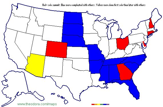
Bellow is a list of the states highpoints I have completed. Some of the dates are my best guess based on when I was there, but most of them are correct.
State High Point Elevation Date completed
Arizona Humphreys Peak 12635 10/4/1997
Arkansas Magazine Mtn. 2755 1/31/1998
Mississippi Woodall Mtn. 808 1/31/1998
Alabama Cheaha Mtn. 2409 2/1/1998
Florida Britton Hill 347 2/1/1998
Missouri Taum Sauk Mtn. 1774 3/18/1998
New Hampshire Mt. Washington 6290 5/23/1998
Connecticut Mt. Frissell - S. Slope 2382 5/24/1998
Delaware Ebright Azimuth 444 5/24/1998
Rhode Island Jerimoth Hill 814 5/24/1998
Ohio Campbell Hill 1552 7/21/1998
Georgia Brasstown Bald 4786 3/19/1999
North Dakota White Butte 3508 4/3/1999
South Dakota Harney Peak 7244 4/3/1999
Nebraska Panorama Pt. 5426 4/4/1999
Colorado Mt. Elbert 14433 9/19/1999
Tennessee Clingman's Dome 6645 6/16/2004
North Carolina Mt. Mitchell 6686 6/19/2004
South Carolina Sassafras Mtn. 3562 6/19/2004
How is it that you decided to do highpointing? I don't think that I had even heard of it until you started to do it.
Back when I was working as trainer, I had started to try to visit every state, and decided that was too easy and not really doing anything too amazing for me.
One weekend in the fall, I decided to get out of 100 degree heat of Phoenix (okay it might have only been in the 90's) and drove up to Flagstaff to climb Humphreys Peak, but when I got up there, I was turned away at the tree level by a snow storm/blizzard. I had showed up there in shorts and a short sleeve shirt, I just happened to have a jacket in my trunk, so I walked hiked to the tree line and turned around when men started to come down with icicles in their beards, very red noses.
I went back a few weeks later, and it was a beautiful day for a hike.
It is funny how men with icicles on their beards can help inspire life quests ... do you remember the day that we tried to hike Humphrys? I swear the snow was up to our hips. I think that was in April or May. It is quite a paradox for Arizona! I would imagine that there are quite a few states where by going to the high point you get a very different point of view than if you were to just see the geography of the area around a city.
I think I have been turned around more on Humphrys because of weather then I have any where else. When you live down in the valley, its just hard to believe that its still winter up there.
Mike and I climbed Humphrey's together and then climbed it another time with Logan. It was blowing so hard the time we climbed with Logan that we had to hold on to him to keep him from blowing off the mountain. The 1st time we climbed it we met two Northern Arizona students on the top. I knew that none of us would get back to our cars before dark and when I asked if they had flashlights they said "no, we won't need them". I told them that we had flashlights and that when it got dark to just sit down and wait until we arrived so we could help them off the mountain - which we did. It was so dark that you couldn't see your hand in front of your face. By the time we got to them they had come accross three more hikers who appreciated our help too.
Mike, we ought to climb King's Peak next summer. It's a long walk up (30 miles round trip)but I'm sure we can do it if we take two or three days.
Uhum. Everyone keeps forgetting that i was on that hike as well.
This was a great hike story mike... I look forward to other entries.
It will be 4 years next summer since any of us got a high point. Let pick a date and get one this summer. I would be happy to get UT, ID, OR, or MT. I have a rope if you want to do ID I can see if the Air Force has a trip up Hood if you want to do OR. They normally go in May/June before the crevasses open up.
I feel really bad that I did not remember you on the hike with Dad, Logan and me. I had remembered Dad and Logan as they were hiking buddies. I remember you helping Logan as well, keeping him moving. I am a rather odd hiker, I am very slow at starting, but once I find my pace I can go forever, I am sure that annoys some, but that works for me.
I am up for a highpoint attempt this summer, I would do anything in the western US, other then AZ as I think most of us have that one (sorry Dave). I think WY is out due to time, cost and difficulty, but the rest of them are doable for sure. Let me know when and where. Could we do WA before the Sib reunion?
I don't know what I am up for because I don't know yet what I will be doing in the summer ... but let me know if you plan a highpointing trip so that I can at least think about going!
I think I might have done AZ. I must have been hiking with Charlie that’s why no one can remember him being there.
I don’t know if they will let us do Rainer with out something else on the resume like hood. At this point, the Air Force does not have Hood on the calendar I can ask about Rainer. I think it would take 3 or 4 days extra to climb.
Post a Comment